Pinpano – 360° Panorama Navigation
With only a few pictures, PinPano caputures a 360° panorama display of a local environment.
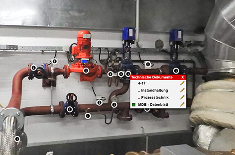
At first glance, the human eye naturally sees, finds and processes components or characteristics of a certain object, i.e. the data sheet of a pump.

Motivation
Everything built or constructed by humans changes over time. It ages, changes it’s appearance or shows signs of usage. A certain service and maintenance is required.
In the age of digitalization, 3D-models are an inherent part of and standard in almost every planning. Architects, engineers and technical drawers use 3D-models to visualize their ideas, illustrate the tasks, picture the scope of work to be done, identify the interfaces to other trades / projects / systems and answer many other questions.
This approach is surely right during the periods of planning until bringing into service. However, requirements change once operation starts: plants age, are altered or repaired, plant parts are substituted, usage / operation changes the millimetric precise dimensions and thus, the actual conditions are not according to the model anymore.
Even documents, allocated to different components or assembly parts, change over time. Many of them even become invalid, like for example inspection certificates, who have to either be renewed regularly or due to revisions.
In former times, piles of folders were filled with paper information. Today, hard drives with countless folders and different versions of data files are used in day-to-day business. Without a digital Document Management System, it is hard to keep track of the last and current version. Even to find documents is a challenge for the user. Scarcely anybody can remember the different numbers and conventions or the filling places. A visual connection of the data files with real objects in our analog world is missing.

… but a picture could create the natural link for the human eye.
For this reason, pinpano is perfectly suitable to access information fast and easy.
For this reason, pinpano panorama photography offers unbeatable benefits:
- Little expediture of time
- Low costs
- Easy update
Day-to-day examples in operational business illustrate the usage of pinpano:
- Sudden breakdown: an instruction manual is needed and can be used in an instant.
- The company responsible for maintenance working on-site is looking for the latest version of a component´s data sheet and can access it right.
- A general remote diagnosis has to be posed and is, due to the actuality of the panorama pictures, readily available.
- Prior to starting work on the location, Sub-contractors need detail information and have them at hand.
In connection with the ITECS software “PIN ProjectServer”, pinpano facilitates the maintenance workflow of plants and buildings. The efficient planning of maintenance operations is done foresighted. Deadlines are transparently monitored with a simple traffic-light system. Certification organizations like DEKRA, TÜV or fire control can inspect if documents, like maintenance – inspection certificates, are up-to-date. The correspondent remote access to the system can easily be granted.
How does it work?
Reaching a pinpano-experience with the typical navigation is very easy:
- Define the camera positions together with the customer (on-site).
- Take the panorama pictures (on-site).
- Deliver the camera positions and pictures to the server.
- Locate the “Points of Interest” on the panorama picture and allocate the documents (i.e. data sheets, inspection certificates, maintenance reports)
